


Dive Site - USS Pilotfish (SS-386)
| Dive Site - USS Pilotfish (SS-386) | |||
| Dive Location: | City / Island: | ||
| USS Pilotfish (SS-386) | Bikini Atoll | ||
| Country: | Rating: | Max. Depth: | Difficulty: |
| Marshall Islands |  |
52 m | Advanced Open Water plus Deep |
| Aquatic Name: | Water: | Altitude: | |
| - | Salt | 0 m | |
| GPS Latitude: | GPS Longitude: | GPS Datum: | |
| 11° 36.567′ N 11.60945° N 11° 36′ 34.02″ N |
165° 29.463′ E 165.49105° E 165° 29′ 27.78″ E |
Google Map | WGS84 |
| 1 dive at this location: | |||
| 374 | |||
| Map: | |||
 |
|||
| Comments: | |||
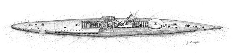
| USS Pilotfish (SS-386) is a US Navy submarine 95 metres (311.8 feet) long and weighing 2424 standard tons submerged. She was barely three years old when assigned to the Operation Crossroads target fleet. She was submerged in 52 metres of water and moored at a keel depth of 17 metres at a range of approximately 275 metres from the point of the "Test Baker" underwater atomic blast on 25 July 1946. The USS Pilotfish now lies with a 30–40 degree list to port, with the stern partially buried in the sand. The plating between the frames of the after torpedo room is dished to a depth of about 150 mm. The superstructure and tank tops are also dished in several places, and the superstructure plating has numerous tears and holes. GPS: 11° 36.567' N, 165° 29.463' E See also: https://en.wikipedia.org/wiki/USS_Pilotfish_(SS-386) |
|||